UC Davis scientists help vulnerable communities understand and prepare for earthquakes like the one that devastated San Francisco in 1906. Soon after that quake, Davisville resident George Pierce Jr. climbed over debris to reach the state attorney general’s office where he filed paperwork that helped establish the Davis campus.
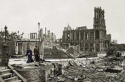
1906 Earthquake Photo: Emanu-el Synagogue, Sutter and Powell Streets, courtesy the San Francisco Public Library
Earthquake safety
For researchers at UC Davis’ Center for Geotechnical Modeling, the question isn’t whether another major earthquake will rock California, it’s a matter of when and where.
With new advances in technology, particularly in computer modeling, researchers are on the forefront of earthquake forecasting that will save lives and assist emergency planners. Their research also provides critical data to civil engineers for building safer roads, tunnels and bridges and retrofitting existing ones. The nation’s largest earthquake-simulation centrifuge—located at the center—demonstrates what happens to soils and structures like dams, bridges and BART tunnels during high-magnitude quakes.
UC Davis engineering professor emeritus I.M. Idriss has been involved in the follow-up analysis of every major earthquake since the 1964 Alaska quake, including those at San Fernando, Mexico City, Loma Prieta, Northridge and Kobe. His research on soil mechanics and foundation engineering across several decades has influenced the construction of dams, nuclear power plants, office buildings, homes, hospitals, railways and bridges worldwide.
UC Davis engineering alumni coordinated the Golden Gate Bridge seismic retrofit and have contributed to the construction of a new span for the Bay Bridge, the nation’s busiest toll bridge.